To leave feedback or to ask questions, go to the contact page.
Water Rights and Mt. Pleasant Releases
 In the mid-1880s, the Texas Legislature adopted a system that authorized the appropriation of water use by the state. This appropriations system (or prior appropriations system) requires those wanting to use the State’s surface waters, including the Franklin County Water District (District), to file and seek state permission through the Texas Commission on Environmental Quality (TCEQ). Under this system, “first in time, first in right”, the earlier established water users were deeded to have a senior priority to use the water over junior water right holders. Anyone now wishing to use surface water in Texas (with only a few exceptions) is now required to hold such a certificate or receive new permission from the state in the form of a "Certificate of Adjudication" or “water right.”
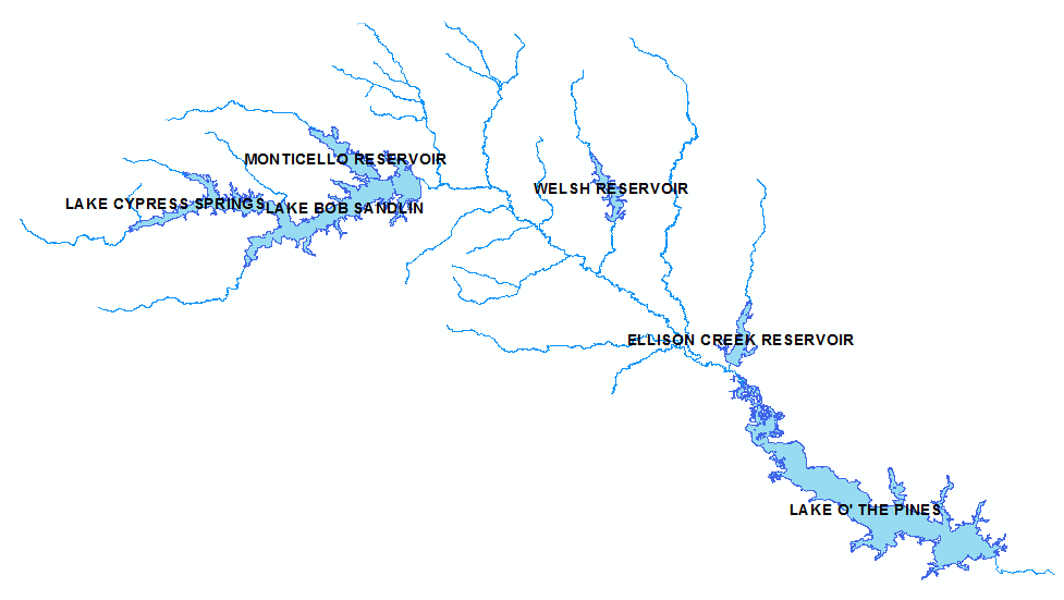
The District owns a water right granted by the State, through TCEQ, that provides the District the ability to hold (impound), sell, divert, and use water from Lake Cypress Springs. In addition to being granted the right to use water, the District is required and obligated to meet all senior downstream water right calls of senior priority and abide by water contracts established outside of the certificate. These other water right owners exist throughout the Cypress River Basin. Through close coordination and communication of operations, the various stakeholders in the basin are able to optimize water uses and work together for a basin-wide understanding of prioritization.
The table below lists the major basin water right stakeholders and their respective impoundments, priorities, and water right certificate numbers.
|
Owner/Entity |
Lake |
Priority Date |
Certificate of Adjudication # |
|
Lone Star Steel Company |
Ellison Creek Reservoir |
1942 |
04-4582 |
|
North East Texas Municipal Water District (NETMWD) |
Lake O' the Pines (LoTP) |
1957 |
04-4590 |
|
Franklin County Water District (District) and the City of Mount Pleasant (CoMP) |
Lake Cypress Springs (LCS) |
1966 |
04-4560B |
|
Titus County Fresh Water Supply District (TCFWSD) |
Lake Bob Sandlin (LBS) |
1971 |
04-4564 |
As shown in the table above, the District owns water right 04-4560B, giving the District the right to impound a specific volume of water at LCS. Additionally, notice that although the District is upstream of all other reservoirs, the District's priority (1966) is not the most-senior in the basin. This means that water entering LCS cannot be held by the reservoir until the water rights of downstream senior water right owners have taken their allotment downstream. Both Ellison Reservoir (1942) and LoTP (1957) have priority dates that are senior to the Districts, and both are downstream of LCS.
Certificate 04-4560B is the third version (original, then A, and then B) of the water right that has been amended for various reasons. The table below outlines the certificate versions.
|
CoA Version |
Purpose/Change |
|
04-4560 |
Original Certificate providing, among other things, the District’s authorization to impound, operate, and manage Lake Cypress Springs. |
|
04-4560A |
Water Right Purchase to amendment CoA 04-4560 to sell a portion (3,590 ac-ft) of water to TCFWSD for a lump sum amount of $3,300,000 and an annual M&O payment of $90,000 (adjusted for yearly CPI) for the useful life of the reservoir. |
|
04-4560B |
Administrative amendment to turn the portion of TCFWSD-owned water from 04-4560A over to CoMP. |
In February of 1997, the District sold a portion of their water right in CoA 04-4560A to Titus County Fresh Water Supply District (TCFWSD), who subsequently sold the water right to the City of Mount Pleasant (CoMP). In purchasing a portion of the water right 04-4560B, the CoMP is allowed to divert no-more than 3,590 acre-feet of water per year from the firm yield of Lake Cypress Springs. One acre-foot of water is a unit of volume equal to the volume of a sheet of water one acre in area and one foot in depth; 43,560 cubic feet. This total volume (3,590 acre-feet) is approximately 1 ft. of water in the reservoir that must be released per year.
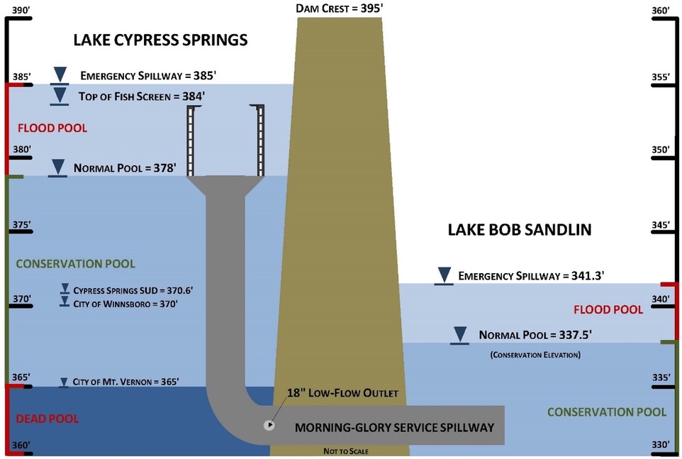
The water right purchase by the CoMP obligates the District to deliver up to the 3,590 ac-ft per year to the CoMP through the dam downstream into Lake Bob Sandlin, where the CoMP can then take the water from LBS for municipal use. This process begins in January with a request from the city for a specific target volume of water to be released. Although the maximum request can be 3,590 ac-ft, the CoMP does not need the full amount to meet their system demands, so the requested volume has always been less than the maximum. The District then uses this target volume to base its releases of obligated water downstream into LBS where it can then be diverted for use by the CoMP. The District, based on a clear set of rules agreed upon by the basin stakeholders, attempts to minimize water surface impacts to LCS, particularly in the summer months, by scheduling releases in the early parts of January/February and later in the year. By working closely with the CoMP and the other basin stakeholders, the District can meet its obligations downstream while trying to minimize the drawdown of the reservoir. With that said, the District is required to release the annual water called-upon by the CoMP regardless of season, lake elevation, or weather conditions. In times of drought, even when the reservoir is already low, the District is still obligated to release the volume requested by the CoMP each year. Because the District has a fixed spillway (as opposed to a gate system), the physical delivery of this water must be met through the 18" low-flow outlet located on the morning-glory service spillway. The physical delivery of this water through the dam is further explained below.
There are only a few various ways water impounded in LCS can leave the reservoir:
1. The Morning-Glory Service Spillway
2. The 18" low-flow outlet
3. The emergency spillway
4. Wholesale municipal use through customer diversions
5. Evaporation, transpiration, or seepage
Below is a schematic (not-to-scale) that outlines the working elevations and the hydraulic elements of LCS. As shown below, the primary method that water leaves the reservoir is through the morning-glory service spillway. This spillway is a 10'X10' L-shaped box culvert that only will convey water after the water reaches an elevation of 378' mean sea level (m.s.l.). This is considered the normal pool or "conservation pool" of LCS. The spillway is affixed with a fish screen up to 384' m.s.l<. to prevent grass-carp from entering LBS. The low-flow outlet is an 18" penetration into the morning glory service spillway that the District can open with a set of valves located at the dam. As discussed above, this low-flow outlet is only used to deliver obligated water to the CoMP or other senior downstream water rights holders. The low-flow outlet is not able to convey a large amount of water and is only opened if the level of LCS is below the conservation pool elevation. If the low-flow outlet is opened in these situations, it is only capable of lowering the LCS reservoir approximately 1-foot in 1-month. Another component, the emergency spillway is situated at elevation 385' m.s.l. Although useful in the event of a 500+ year storm event, the emergency spillway is for emergency use only and has not been engaged in the history of the reservoir. Additionally, the District has 3 wholesale customers (intake elevations shown in the schematic below) that divert raw water from the lake for municipal use:
1. Cypress Springs SUD - 370.6 m.s.l.
2. City of Winnsboro - 370.0 m.s.l.
3. City of Mt. Vernon - 365.0 m.s.l.
The water right obligations the District must meet within the Cypress Basin, coupled with the limits of our hydraulic capabilities, can make the operations of the lake seem confusing and unclear, particularly in times of drought or flood. The District makes this information available in hopes that understanding the complexity of reservoir management will clarify why and how the District does what it does.
District U.S. Army Corp of Engineers (USACE) permitting process FAQ.
The purpose of this FAQ is to clarify common questions the FCWD receives from the public about the United States Army Corp of Engineers (USACE) permitting process. This document should be used to support your FCWD permit submission, but primarily the submission of the FCWD USACE Agreement Form and corresponding documentation.
Q. Why am I required to submit the FCWD USACE Agreement Form?
A. Lake Cypress Springs, although owned and managed by the FCWD, also falls under the jurisdiction of the United States Army Corp of Engineers (Corp or USACE). The lake itself is not a Corp-owned reservoir; however, under Section 404 of the Clean Water Act, the Corp has jurisdictional authority over “Waters of the US” which Lake Cypress Springs is considered. The FCWD, as owners of the lake and property lessees, requires the USACE Agreement Form to confirm that the project falls below minimum thresholds set by the Corp, or that the owner has permission from the Corp to construct the proposed project.
Q. If I get a USACE Permit, do I still need a FCWD permit?
A. Yes, in this case the USACE and the FCWD have overlapping jurisdictional authority, and both impose their own rules and regulations.
Q. Is Lake Cypress Springs the only lake in Texas requiring USACE compliance?
A. No. All lakes in Texas are subject to Section 404 rules and evaluations. Property owners on these lakes are also required to abide by the USACE regulations. Other water authorities that manage Texas reservoirs handle abiding by Corp regulations differently.
Q. Will this requirement influence my application fee or contractor requirements? Will my construction cost increase?
A. Generally no. The FCWD has not increased fees to review USACE compliance. We anticipate that most projects will not require further action past signing and adhering to the FCWD USACE Agreement Form. The FCWD does not control construction prices in the area.
Q. What happens if I am unable to confirm agreement of the required statements on the FCWD USACE Agreement Form?
A. Failure to confirm in agreement of the required statements means that the proposed project falls outside of the limits of a USACE no-notice requirement. Generally speaking, this means that the project is too large, too odd, or impacts specially designated USACE areas (wetlands, cultural areas, endangered species, etc.). The project will be required to be permitted through the USACE first, and then proof of the approval will be required as part of your application.
Q. What is considered part of the Total Disturbance?
A. The total disturbance is the amount of material that your project is proposed to MOVE, DEPOSIT, OR REMOVE within lake waters or a wetland.
Q. How is the total disturbance calculated for retaining wall projects?
A. The FCWD has provided the following illustration to clarify how the total disturbance is calculated.
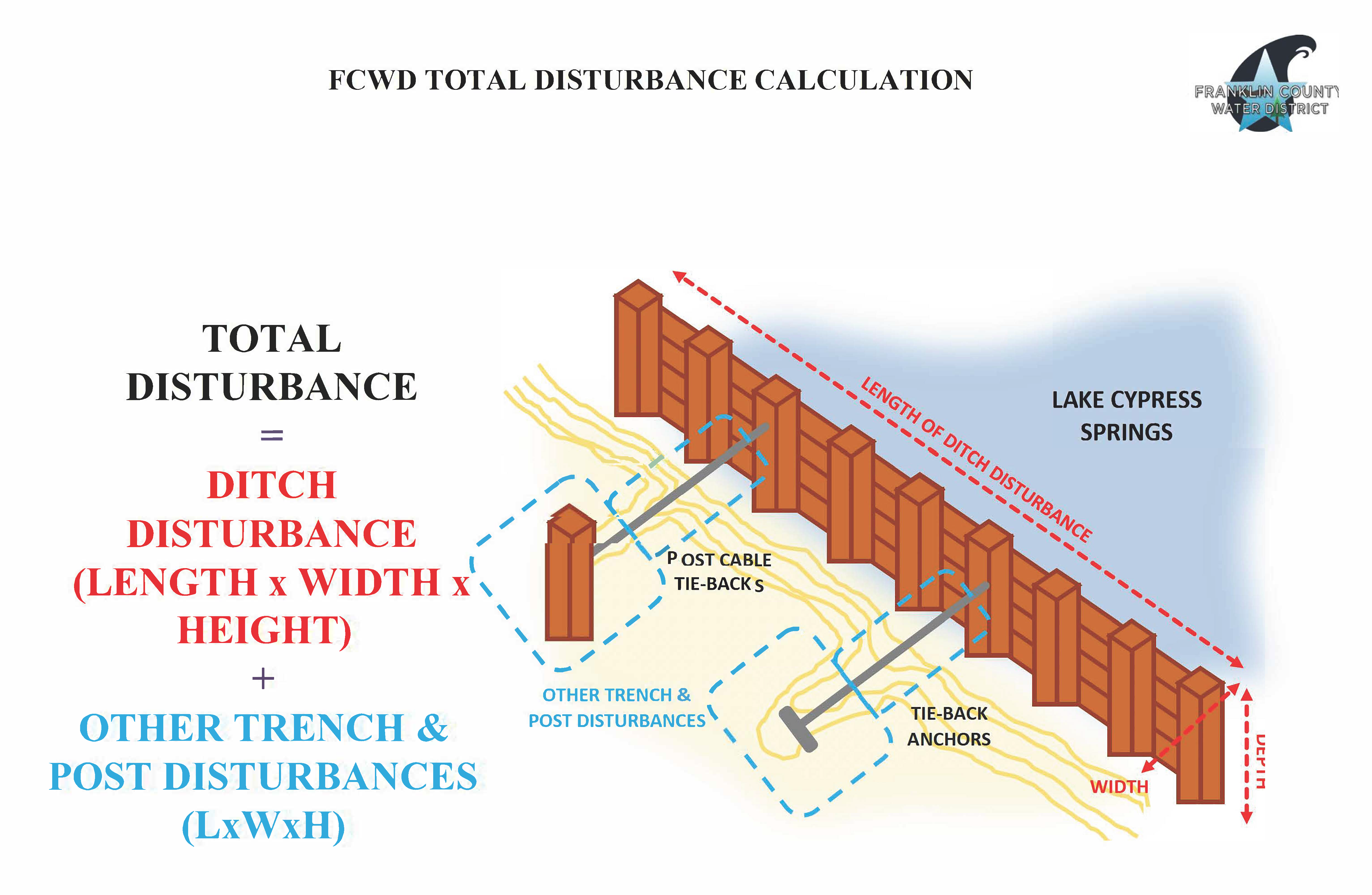
Q. How is the total disturbance calculated for boathouse projects?
A. Boathouse disturbances are typically calculated by multiplying the length x width x depth of the proposed boathouse pilings/footing excavations. If dredging or retaining walls are also proposed, add these disturbances to the boathouse disturbance calculation.
Q. How is the total disturbance calculated for dredging projects?
A. Dredging disturbances are typically calculated by multiplying the length x width x depth of the proposed dredge area/s.<
This FAQ discusses District policies relating to short term rental.
In this FAQ short term rental means the lease, sub-lease, rent, or license of any residential unit or portion thereof on District leased property for a period of less than six consecutive months. No Lessee can allow any leased property, or any residential unit or portion of a residential unit located on District leased property, to be used as a short term rental.
Upon investigation by the District and notification to the Lessee that leased property is being used as a short term rental in violation of these rules, Lessee must demonstrate to the District that the District leased property is no longer being used as a short term rental. Following this initial violation, any future violations of the District Article XI Rules and Regulations will be deemed a default of the Lease that may be terminated by the District.
This FAQ discusses policies relating to closures of boat ramps and Lake Cypress Springs.
The General Manager of the District is authorized and directed to take any and all necessary measures to close the Lake and any public boat ramp on the Lake when the Lake reaches an elevation of 2.50 ft. m.s.l. above conservation pool of 378.00 ft. m.s.l. (or an elevation of 380.50 ft. m.s.l.) or in any circumstances where the General Manager determines such closure is necessary to protect the health and safety of recreation users of the Lake.
This FAQ discusses the requirements to raise and secure all watercraft in boathouses.
The District’s rules require that all boats be restricted, by either tie or obstruction, from floating outside the boathouse perimeter. Any boats found floating free will be removed from the lake at the owners expense.
The District’s rules also require that if a resident is away from their house for more than three days, boats stored in boathouses must be lifted and kept at their maximum height. Any obstruction (top, towers, etc.) that would prevent the boat from being raised as high as possible must be lowered or removed. Lake Patrol will be checking compliance with this rule and notice of violations will be issued for non-compliance.
We appreciate your attention to this as it is in everyones best interest to maintain control of watercraft during elevated water events and to prevent as much damage as possible.
Temporary and Permanent Lowering of Lake Cypress Springs for Flood Protection Purposes
On December 27, 2015, the Lake Cypress Springs (LCS) watershed experienced a historic flooding event that caused lake waters to rise to record levels. The Water Surface Elevation (WSE) rose to a maximum of 383.92 feet above mean sea level (msl) or 5.92 feet above the conservation pool of the reservoir, set constant at 378.00 feet msl. Boats, houses, and boathouses experienced significant damage from the high-water event costing many property owners, including the District, thousands of dollars in damages.
This high-water event, classified as a 350-year storm, resulted in the public's concern over the conservation pool of the reservoir and a question about whether the citizens living around the lake might benefit from a temporary or permanent lowering of the conservation pool to mitigate the severity of a future high-water event or a future event that would engage the emergency spillway. As such, the District hired Carollo Engineers, Inc., (Carollo) to evaluate a variety of hydraulic scenarios to assist the District to understand the benefits and consequences of permanently or temporarily (seasonally) lowering the reservoir.
The results of these evaluations, as related to the lowering of the reservoir, are presented below, as well as my recommendation to the Board of Directors moving forward.
Permanent Lowering of the Reservoir:
In March of 2017, Carollo finalized the Preliminary Engineering Report (PER) that outlined a variety of flood relief mitigation options. As part of this exercise, they were tasked to evaluate an Operational Alternative #6 which included an evaluation of permanently lowering the reservoir.
Carollo completed Water Availability Modeling (WAM) modeling to determine the effects of lowering the reservoir to a new conservation pool. A series of five (5) scenarios were evaluated ranging from 0.5 feet lower than existing conservation pool to 4 feet lower. The results from the WAM analysis are shown below in Table 1.
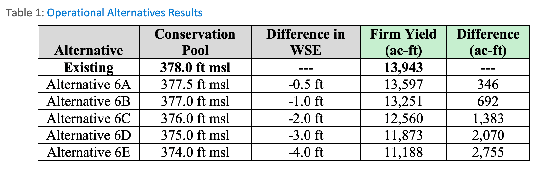
The results show a clear impact on the firm yield of the reservoir if the conservation pool is lowered by any amount.
Carollo's Recommendation: "Given the firm yield impacts and implications to wholesale water contracts, Carollo cannot recommend lowering the conservation pool to provide flooding relief a feasible alternative."
Given the firm yield impacts and implications to wholesale water contracts, Carollo did not recommend that lowering the conservation pool elevation to provide flooding relief as feasible alternative in the PER.
The General Manager made a recommendation and the Board adopted that recommendation based on the PER, to not permanently lower the conservation pool elevation of Lake Cypress Springs to provide flood relief.
Seasonal Lowering of the Reservoir:
The District has received requests from the public requesting that Lake Cypress Springs be lowered on a seasonal basis. The proposal would be to lower the reservoir during the winter months when the threat of a high-water event is elevated and the risk of entering the summer months with a lowered pool is minimized.
Although Carollo was not tasked to evaluate a seasonal lowering of the reservoir through the WAM model, Carollo has indicated in their presentations that any lowering of the reservoir further adds to the risk that the District would enter into a drought-year while the reservoir is low. As such, the District can consider a temporary lowering of the reservoir to have a real, yet undetermined, impact on the firm yield of the reservoir.
In addition to the risk lowering the reservoir has on the District's water supply (see above), Lake Cypress Springs is extremely limited in the physical ability to lower the reservoir. As Carollo has analyzed and documented, the low-flow outlet is used to deliver obligated water to the CoMP or other senior downstream water rights holders. The low-flow outlet is not able to convey a large amount of water and is typically only opened if the level of LCS is below the conservation pool elevation. If the low-flow outlet is opened in these situations, it is only capable of lowering the LCS reservoir approximately 1-foot in 6-weeks.
Carollo's Recommendation: "the low flow outlet is too small to be used to mitigate flooding on the reservoir. The low-flow outlet should continue to be used to deliver water to customers and meet our water right obligations downstream."
Benefit vs. Risk:
In addition to the evaluation of risk to the District's water supply from a permanent or seasonal lowering of the reservoir, the benefit to lakeside residents must be considered.
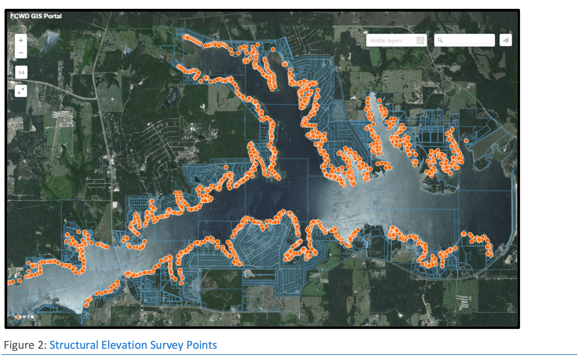
As an exercise in the 2017 PER, Carollo completed an elevation survey around the reservoir. Arroyo Environmental (Arroyo) was hired to provide Carollo with a single x,y,z point for each finished slab elevation around the entire lake. In Figure 2 below, each orange point represents a house and identifies the house's elevation.
The results of this elevation survey show that a majority of the houses around the lake are above the emergency spillway's elevation of 385.0 feet msl (see Graph 3 below). Of the 1,025 houses surveyed, 82 (approximately 8 percent) are below the emergency spillway's elevation of 385.0 feet msl. Additionally, 272 (approximately 26 percent) are above the emergency spillway but below the dam's designed elevation of 395.0 feet msl, and 689 houses (approximately 67 percent) are above the dam's elevation. This means that 961 (approximately 94 percent) houses are above the emergency spillway's elevation.
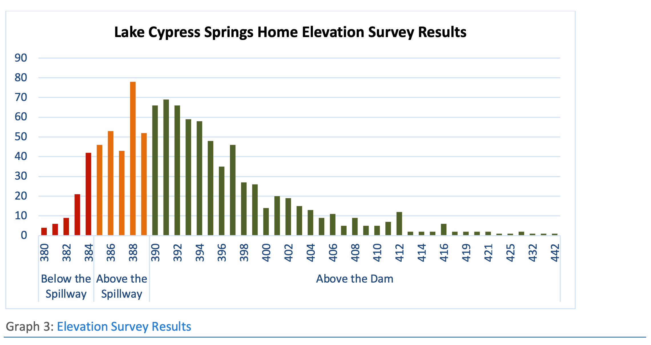
Graph 4 below shows the 82 houses below the spillway's 385.0 feet msl elevation. It also includes houses between 385.0 and 385.5 (17 houses). As shown, there is a right skew toward the higher elevations, with a majority of houses above 383.0.
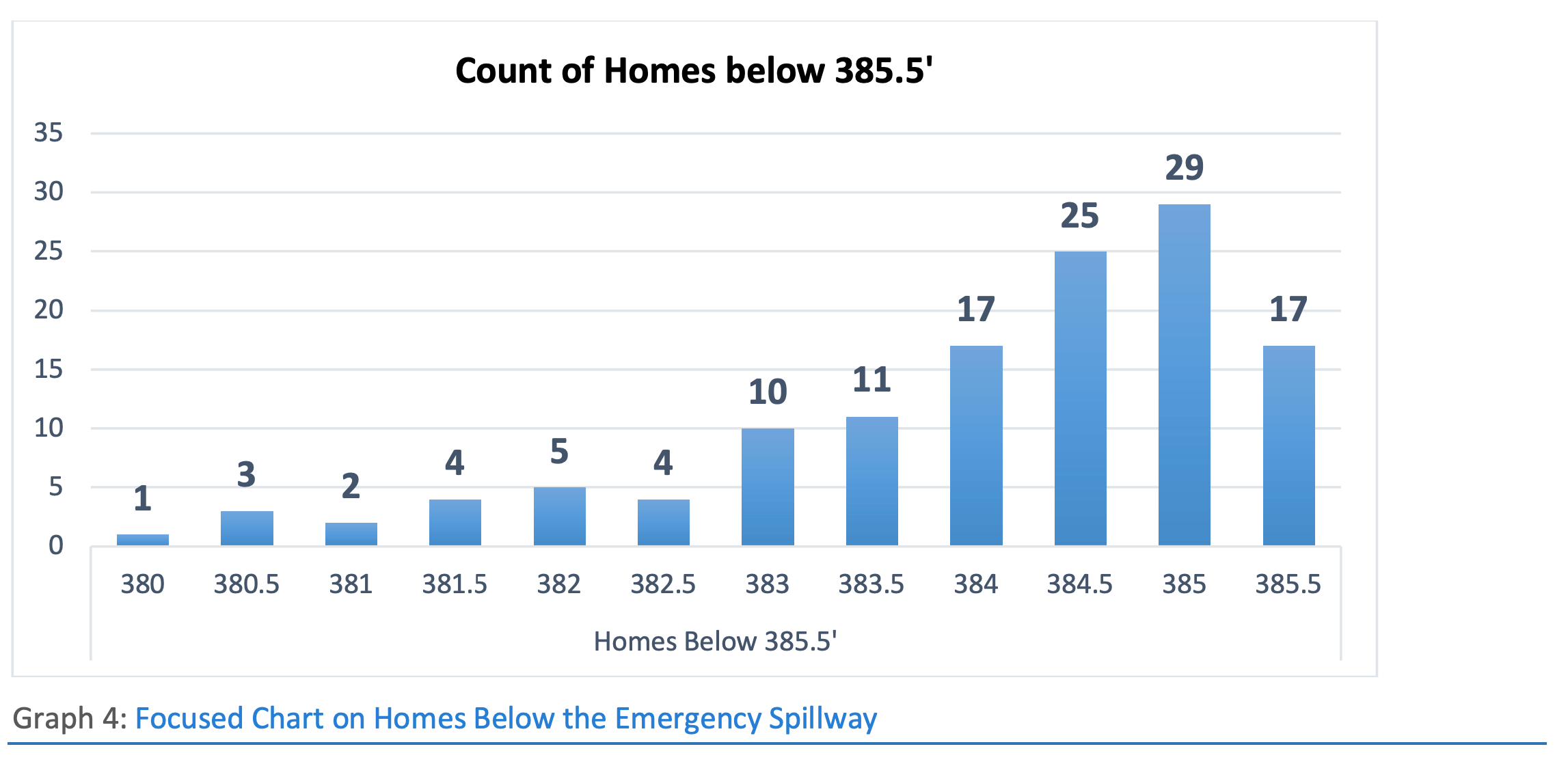
Graph 5 focuses on the December 2015 record high water event showing the number of houses that theoretically flooded based on the survey. Of the 1,025 houses surveyed, only 37 (approximately 4 percent) were below the flood elevation of 383.92 feet msl or 5.92 feet above the conservation pool of the reservoir set at 378.0 feet msl. The vast majority of houses, approximately 96 percent, remained above the record high December 2015 event.
Opinion:
As outlined in the above three (3) sections, there exist multiple risks with limited benefits in the District permanently or seasonally lowering the reservoir to mitigate for the possibility of a future high-water or flood event.
"It is my opinion that the District should take no action in permanently or seasonally lowering Lake Cypress Springs."
David I. Weidman
General Manager
Understanding Storm Event Modeling
“We had a 100-year flood two years in a row! Now we are having another one? You guys must have your numbers wrong.”
People lacking an engineering background in hydrology often find the concept of a 1-in-100-year storm event to be confusing or misleading. It is sometimes assumed that if an area has experienced the 1-in-100-year flood already, then that means for the next 99 years they don’t need to worry about flooding. Unfortunately, this isn’t the case, and probabilities are hard to understand.
Understanding storm event probabilities can be difficult. Engineers develop hydrologic models that predict the amount of rain that will fall based on historic rainfall events. They then use these predictions to develop hydraulic models that tell us how water will respond in our lakes and rivers. The models developed for the FCWD do just this and help determine the water level rise in Lake Cypress Springs for each storm event, as shown in the table below.
|
Event |
Elevation |
|
2-Year |
379.2 |
|
5-Year |
379.57 |
10-Year |
379.98 |
|
25-Year |
380.62 |
50-Year |
381.4 |
|
100-Year |
382.35 |
500-Year |
384.77 |
So, what exactly does “100-year” storm event mean anyway? If such a storm happened 5 years ago, could you assume that another event of the same magnitude won’t happen for at least 95 more years?
No, in some cases, storms of this degree can happen within weeks of each other, which begs the question, why are they called “1 in 100 year” events if the reality is that they can happen more often than that?
The phrasing “1 in 100 year” leads one to believe that the event will only happen once every 100 years,
but in reality, a 100 year storm event describes the probability that the storm will happen within a given year (in this case 1%).
In layman’s terms, this can be modelled as having 99 red marbles and 1 green marble in a bag. Every year you randomly select one marble from the bag and then return it. Statistically your odds of selecting the green marble are 1 out of 100 each year.
Additionally, selecting the green marble one year does not affect the odds of selecting it again the next year (1 out of 100). The reality is that the green marble could be selected multiple years in a row, but over the course of thousands of years the marble will be chosen an anticipated 1 percent of the time.
This process is how storm event modelling works. The occurrence of a 100 year storm event does not change the probability that the storm will happen the next year. There will still be a 1% chance the storm occurs over the course of the year whether an equivalent event occurred 5, 10, or 20 years ago.
Understanding flood event statistics is helpful in planning for storms, floods, and elevation rises across the lake. In knowing how often a predicted event should occur, one can take steps in mitigating damage created by such event. For example, it is helpful to understand that if you were to live your entire life (average life expectancy of 79 years) in an area that is prone to flooding, statistics suggest you would more likely than not experience a 100 year storm event.
Additionally, there is an approximate 63.4% chance of one or more 100 year floods occurring in any 100 year period.
Statistics are simply models that attempt to predict the randomness of natural occurrences. As with any statistic, the probability over the course of thousands of years will average-out, but this should not be taken as a fool-proof future predictor.
It's a very complex process to give people an accurate representation of risk from flooding. Other factors, such as climate change, add elements of unpredictability and uncertainty to historic-based models. Humans have been measuring rainfall patterns for roughly 100 years in a world that has existed for thousands. To the public, all they want is clear information about future flood probabilities so they can make decisions accordingly; unfortunately, it’s not as easy as it may seem.
Discussion of Sedimentation Causing Flooding
On December 27, 2015, the Lake Cypress Springs (LCS) watershed experienced a historic high water event that caused lake waters to rise to record levels. The Water Surface Elevation (WSE) rose to a maximum of 383.92 feet above mean sea level (msl) or 5.92 feet above the conservation pool of the reservoir, set constant at 378.00 msl. Boats, houses, and boathouses experienced significant damage from the event costing many property owners, including the Franklin County Water District (FCWD or District), substantial economic damages.
As a result of this event, the District has experienced public criticism surrounding the thought that sedimentation that has occurred in the reservoir may be causing an increase in the flooding around the reservoir. The thought is that accumulated sediment at the bottom of the reservoir takes the place of flood-storage, therefore causing additional flooding problems in large storm event.
Although it is true that over time, reservoirs lose capacity due to sedimentation, this document focuses on:
A. Explaining the purpose of the sedimentation survey,
B. Explaining why reservoir sedimentation does not cause an elevated risk of flooding around the reservoir, and
C. Outlining costs and funding sources for a new sedimentation survey to be completed.
(A) The Texas Water Development Board (TWDB) Volumetric and Sedimentation Surveys
The Hydrographic Survey Program began in 1991, when the Texas Legislature authorized the TWDB to develop a non-profit, self-supporting, reservoir volumetric survey program. The Texas Water Code authorizes TWDB to perform surveys to determine reservoir storage capacity, sedimentation levels, rates of sedimentation, and projected water supply availability. Over time, reservoirs lose capacity due to sedimentation.
A volumetric and sedimentation survey was completed in 2003 and then again in 2007. The sedimentation results are shown below in Figure 1: Lake Sedimentation Timeline.

While a volumetric survey only identifies the current bottom surface of a reservoir, a TWDB sedimentation survey identifies the pre-impoundment bottom of the reservoir as well (the bottom when the reservoir was constructed). Sediment core samples are collected throughout the reservoir and correlated with multi-frequency acoustic data signal returns to aid in the identification of the pre-impoundment bottom. A sedimentation survey report includes updated elevation-area-capacity tables, a bathymetric contour map, a sediment volume and annual average sedimentation rates, and a map of sediment thicknesses throughout the reservoir.
In 2007, the TWDB entered into agreement with the U.S. Army Corps of Engineers (USACE), Fort Worth District, for the purpose of performing a volumetric and sediment survey of Lake Cypress Springs. This survey was performed using a multifrequency (200 kHz, 50 kHz, and 24 kHz) sub-bottom profiling depth sounder. In addition, sediment core samples were collected in selected locations and were used in interpreting the multi-frequency depth sounder signal returns to derive sediment accumulation estimates. This survey concluded these things:
| • | The results of the TWDB 2007 Volumetric Survey indicate Lake Cypress Springs has a total reservoir capacity of 66,756 acre-feet and encompasses 3,252 acres at conservation pool elevation (378.0 feet above mean sea level, NGVD29). |
| • | The results of the TWDB 2007 Sediment Survey indicate Lake Cypress Springs has accumulated 3,807 acre-feet of sediment since impoundment in 1970. |
| • | Lake Cypress Springs loses approximately 100 acre-feet of capacity per year. The majority of the sediment accumulation has occurred within the main body of the lake, with the thickest deposits in the submerged Big Cypress Creek channel. The maximum sediment thickness observed in Lake Cypress Springs was 7.2 feet. |
| • | The TWDB considers the 2007 survey to be a significant improvement over previous methods (2003 survey) and recommends that a similar methodology be used to resurvey Lake Cypress Springs in 10 to 20 years or after a major flood event. |
(B) Does sedimentation cause localized flooding around the lake
Although it is a common misconception that sedimentation can cause localized flooding due to a loss in the reservoir's capacity, under most circumstances, this is not true. Albeit true that reservoirs lose capacity due to sedimentation, sedimentation will not cause flooding for two primary reasons:
1. Deposits are primarily located at the bottom of the reservoir, and
2. The reservoir remains at-or-near conservation pool permanently.
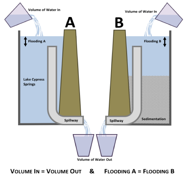
In an attempt to illustrate sedimentation scenarios, please see Figure 2 below. The Scenario labeled "A" represents a reservoir with no sedimentation, where the scenario labeled "B" has experienced extreme sedimentation (~50%). As the figure showcases, the water that comes into the reservoir will equal the water that is released from the reservoir thought the spillway. In other words, "volume of water in = volume of water out." Because of this fact, the amount of water that runs into the reservoir from a large storm event will simply "pool" until it has had time to be released through the spillway. The sedimentation in the bottom of the reservoir has not effect on the rise in water surface elevation in the reservoir.
(C) Cost and Possible Funding Sources
In the past, the USACE provided a 50% match on volumetric and sedimentation surveys completed by entities such as FCWD. This funding source, however, has been discontinued and is no longer available. It is unclear if it will return.
There are two identified funding sources that have been identified as a potential for the FCWD.
1. Water Marketing Grants through the Bureau of Reclamation (BoR)
| • | Through this grant program, the BoR will provide grants to conduct planning activities in developing a water marketing strategy to establish or expand water markets or water marketing transactions. Water marketing refers to water rights transactions, include the lease, sale or exchange of water rights, undertaken in accordance with state and federal laws, between willing buyers and sellers. |
| • | A water market refers to a formal arrangement, based on a set of rules and/or water management agreements, to allow for water rights transactions within a specific geographic area. |
| • | A “water marketing strategy” consists of planning activities including engineering, hydrologic, legal, economic, and other types of analysis, and the development of rules, legal agreements, software and logistical arrangements for water marketing. |
| • | The Fiscal Year 2018 Funding Opportunity is currently being developed. |
2. Drought Response Program
| • | The BoR's Drought Response Program supports a proactive approach to drought by providing financial assistance to water managers to: develop and update comprehensive drought plans (drought contingency planning), and implement projects that will build long-term resiliency to drought (drought resiliency projects). |
| • | Applicants may request up to $200,000 in Federal funding per drought plan or plan update. Applicants may request up to $300,000 in Federal funding per resiliency project. A 50% non-Federal cost share contribution is required (including non-Federal funds, donations, contributions, and/or in-kind services). In limited cases, a cost-share reduction or waiver may be granted. |
| • | Applicants for drought resiliency projects funding must submit their proposals by 4:00 p.m. MST on Tuesday, February 13, 2018. We missed it for this year. |
| • | Program areas available for funding include:
a. Contingency Planning b. Resiliency Projects c. Emergency Response Actions |
| • | "Drought Resiliency" is defined as the capacity of a community to cope with and respond to drought. Under this element of the program, the BoR will fund drought resiliency projects that will help communities prepare for and respond to drought. Typically, these types of projects are referred to as "mitigation actions" in a drought contingency plan. Projects must meet one of the following goals:
a. Increase the reliability of water supply and sustainability b. Improve water management and increase operational flexibility c. Implement systems to facilitate voluntary sale, transfer or exchange of water d. Provide benefits for fish and wildlife and the environment e. Mitigate poor water quality caused by drought. |
Although we consider it plausible, it's not entirely clear if either of these grant programs would allow for a sedimentation survey to be developed. Each of these grants would likely allow for the sedimentation survey to be part of a larger work effort.
In summary, the low flow outlet is too small to be used to mitigate flooding on the reservoir. The low-flow outlet should continue to be used to deliver water to customers and meet our water right obligations downstream.
| • | The Water Marketing Grants, at a minimum, a sedimentation survey would need to be a single element of a much larger undertaking. FCWD would need to express a need to develop a marketing strategy to buy, sell, permit, divert, or consume water. Carollo has attached a summary list of the previous grant winners and the topic on which the grant was funded. |
| • | To be successful in being awarded a Drought Response Grant, the FCWD would need to express a need in updating their drought contingency plan. To develop more accurate numbers of firm yield and determine drought stages, an updated sedimentation survey could be part of this process. Carollo has included a FAQ and Fact Sheet for this grant program attached to this document. Additionally, the 2018 deadlines have past for this application and would need to be considered in the 2019 round:
○ Feb 7: Drought Contingency Planning Applications Due |
| • | To be successful in being awarded a Drought Resiliency Grant, FCWD would be required to showcase a need in the capacity of the FCWD community to cope with and respond to drought. Additionally, the 2018 deadlines have past for this application and would need to be considered in the 2019 round:
○ Feb. 13: Drought Resiliency Projects Applications Due |
Carollo reached out to Arroyo Environmental to provide the FCWD with a cost to complete a volumetric and sedimentation survey in 2016. This cost totaled $52,480. The details of the estimate are attached to this document. Note: This cost estimate reflects the prices for 2016.
Discussion of the Morning Glory Preventing Flooding
On December 27, 2015, the Lake Cypress Springs (LCS) watershed experienced a historic flooding event that caused lake waters to rise to record levels. The Water Surface Elevation (WSE) rose to a maximum of 383.92 feet above mean sea level (msl) or 5.92 feet above the conservation pool of the reservoir, set constant at 378.00 msl. Boats, houses, and boathouses experienced significant damage from the event costing many property owners, including the district, thousands of dollars in damages.
As a result of this event, the District has experienced public criticism surrounding the use of the low-flow outlet pipe located inside the Morning Glory Spillway. The claim is that the FCWD can control the water level in LCS by opening or closing the low-flow outlet during flooding times. This letter will (A) present factual information about the low-flow outlet (B) clarify its intended use and (C) showcase the outlets inability to control flooding on the reservoir.
(A) The Morning Glory and Low-Flow Outlet
The LCS dam is a 5,230-feet long earth-fill embankment with a top crest at an elevation of 395.0 feet above msl, NGVD29 (msl). To control the release of flows, the dam was constructed with a morning glory-style service spillway located at the south end of the main dam embankment with a spillway fixed at the elevation of 378.0 feet above msl. The service spillway has a fish screen from 378.0 msl to 384.0 msl, one foot below the emergency spillway elevation. The speed at which water flows over the spillway is determined by the water pressure in LCS and in Lake Bob Sandlin (LBS) downstream.
In addition to the Morning Glory, the District does maintain and operate a low-flow outlet. The low-flow outlet is an 18" penetration into the morning glory service spillway that the District can open with a set of valves located at the dam.
(B) The purpose of the Low-Flow Outlet
In the mid-1880s, the Texas Legislature adopted a system that authorized the appropriation of water use by the state. The appropriations system (or prior appropriations system) requires those wishing to use the State’s surface waters to file and seek state permission through the TCEQ. Under this system, “first in time, first in right,” the earlier established water users were deeded to have a senior priority to use the water over junior water right holders. Anyone wishing to use surface water in Texas (with only a few exceptions) is now required to hold such a certificate or receive new permission from the state in the form of a “water right.”
In February of 1997, FCWD sold a portion of their water right in CoA 04-4560A to Titus County Fresh Water Supply District (TCFWSD), who subsequently sold the water right to the City of Mount Pleasant (CoMP). In purchasing a portion of the water right 04-4560B, the CoMP is allowed to divert no more than 3,590 acre-feet of water per year from the firm yield of Lake Cypress Springs. One acre-foot of water is a unit of volume equal to the volume of a sheet of water one acre in area and one foot in depth; 43,560 cubic feet. This total volume (3,590 acre-feet) is approximately 1 ft. of water in the reservoir that must be released per year.
The water right purchase by the CoMP obligates the FCWD to deliver up to the 3,590 ac-ft per year to the CoMP through the dam downstream into Lake Bob Sandlin, where the CoMP can then the water from LBS for municipal use. This process begins in January with a request from the CoMP for a specific target volume of water to release. Although the maximum request can be 3,590 ac-ft, the CoMP does not need the full amount to meet their system demands, so the requested volume has always been less than the maximum. The District then uses this target volume to base its releases of obligated water downstream into LBS where it can then be diverted for use by the CoMP.
The District, based on a clear set of rules agreed upon by the basin stakeholders, attempts to minimize water surface impacts to LCS, particularly in the summer months, by scheduling releases in the early parts of January/February and later in the year. By working closely with the CoMP and the other basin stakeholders, the District can meet its obligations downstream while trying to minimize the drawdown of the reservoir. With that said, the District is required to release the annual water called-upon by the CoMP regardless of season, lake elevation, or weather conditions. In times of drought, even when the reservoir is already low, the District is still obligated to release the volume requested by the CoMP each year. Because the District has a fixed spillway (as opposed to a gate system), the physical delivery of this water must be met through the 18" low-flow outlet located on the morning-glory service spillway.
The FCWD has a series of water rights through TCEQ enabling the impoundment of water (forming LCS), and enabling the sale of their impounded water through water contracts and agreements with various municipalities. The current obligations to deliver raw water include:
• Cypress Springs Special Utility District (CSSUD)
• City of Winnsboro
• City of Mt. Vernon
• City of Mount Pleasant
These water obligations to the entities through water contracts/agreements are very important to the District's revenue stream, but more importantly, are considered a legal obligation that can only be met by selling firm-yield water from the reservoir.
(C) The Low-Flow Outlet Related to Reservoir Flooding
As discussed above, this low-flow outlet is only used to deliver obligated water to the CoMP or other senior downstream water rights holders. The low-flow outlet is not able to convey a large amount of water and is typically only opened if the level of LCS is below the conservation pool elevation. When the low-flow outlet is opened in these situations it is only capable of lowering the LCS reservoir approximately 1-foot in 6-weeks.
To better illustrate the size of the low-flow outlet with respect to the volume of LCS, analogous data was created between the lake and an average sized swimming pool (20,000 gallons). This comparison can be found in the figure below.
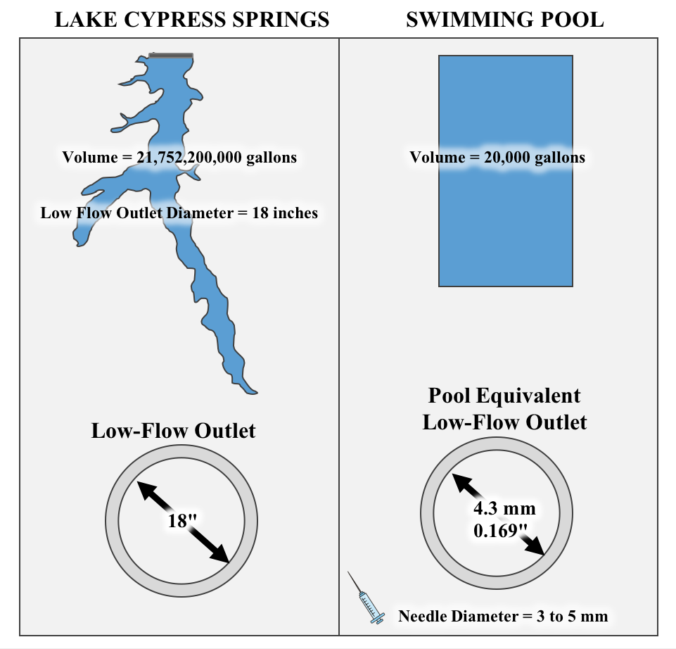
This analogy should illustrate that the task of flood prevention through the discharge of water through the low-flow outlet cannot be accomplished. The outlet being open or closed during a flood event makes an insignificant amount of difference in the ability to discharge more flows out to Lake Bob Sandlin.
In addition to this analogy, the table below showcases that the low-flow orifice has the hydraulic capability of lowering the reservoir approximately 7.82 inches in 30 days, or about .26 inches per day.
|
LCS Surface Area (acre) |
Low-Flow Outlet Discharge (acre-ft/day) |
Low Outlet Depth Discharge per Day (in) |
Low Outlet Depth Discharge After 30 Days (in) |
Time to Drop LCS Depth 1 Foot (Days) |
|
3,252 |
70.64 |
0.26 |
7.82 |
46 |
As shown above, in a 24 hour rain event the low-flow outlet would account for a less than half inch drop in mean sea level elevation. Over a month’s span of the outlet being fully opened, the lake would only drop less than 8 inches. Additionally, it would take roughly 46 days for the lake level to drop one foot.
In summary, the low flow outlet is too small to be used to mitigate flooding on the reservoir. The low-flow outlet should continue to be used to deliver water to customers and meet our water right obligations downstream.